

$175,000
Unplug & Reconnect with Nature – Exclusive Waterfront Cabin with Creekside Serenity!
Mahood Lake, British Columbia
-
Sqft: 2,400
-
Acres: 5.70
 BOAT ACCESS ONLY
 BOAT ACCESS ONLY
 BOAT ACCESS ONLY
 BOAT ACCESS ONLY
 BOAT ACCESS ONLY
 BOAT ACCESS ONLY
 BOAT ACCESS ONLY
 BOAT ACCESS ONLY
 BOAT ACCESS ONLY
 BOAT ACCESS ONLY
 BOAT ACCESS ONLY
 BOAT ACCESS ONLY
 BOAT ACCESS ONLY
 BOAT ACCESS ONLY
 BOAT ACCESS ONLY
 BOAT ACCESS ONLY
 BOAT ACCESS ONLY
 BOAT ACCESS ONLY
 BOAT ACCESS ONLY
 BOAT ACCESS ONLY
 BOAT ACCESS ONLY
 BOAT ACCESS ONLY
 BOAT ACCESS ONLY
 BOAT ACCESS ONLY
 BOAT ACCESS ONLY
Description
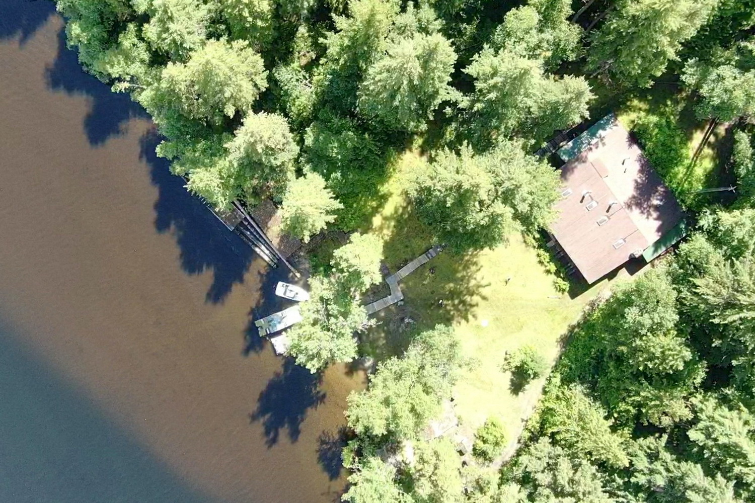
Secluded Wilderness Retreat on Mahood Lake
Once known as the Wells Grey Camp, this hidden gem has been tucked away on Mahood Lake for decades. Nestled in a protected bay and accessible only by boat or snowmobile when the lake is frozen, this off-grid retreat is the perfect place to unplug and reconnect with nature.
Designed as a true escape from modern distractions, this serene property invites you to fish, unwind, and enjoy the peaceful surroundings. A year-round creek flows beside the main building, adding to the tranquility of this remote hideaway.
The spacious lodge offers approximately 2,400 sq. ft. of living space, comfortably accommodating 10 to 12 guests. Propane powers the lighting, heating, fridges, and stove, with wiring in place for generator use. The sale includes all furniture, appliances, inventory, and a 10,000-watt generator, with only the sellers’ personal belongings to be removed.
Offered on an "as is, where is" basis under government leasehold, this is a rare opportunity to own a truly private retreat in the heart of nature.
Annual Lease pmt: $2,784.00
Lease Exp. Nov 2029
AREA DATA & RECREATION Features
Mahood Lake is a lake in the South Cariboo region of the Interior of British Columbia in Wells Gray Provincial Park. It is drained by the Mahood River, a tributary of the Clearwater River which has cut a deep canyon into Cambrian rocks and Pleistocene glacial moraines. Mahood Lake is fed by the short Canim River, which drains nearby Canim Lake to the west via Canim Falls and Mahood Falls.
The lake is 629 metres in elevation, 197 metres deep at its deepest point, approximately 33.5 km² in area, 21 km (13.0 mi) in length (east to west) and a maximum of 2.2 km (1.4 mi) in width. Mount Mahood is immediately south of the lake and rises to 1,812 m (5,945 ft).
This deep valley was carved by glaciers, but there are remnants of lava flows north of the east end of the lake and along the Canim River upstream.
The Canim River is the major inflow. It is 8 km (5.0 mi) long, draining Canim Lake, and most of this distance is through a rugged gorge carved in lava. The river drops 142 m (466 ft) between the lakes, partly accounted for by two waterfalls, Canim Falls and Mahood Falls. The other major inflow is Deception Creek on the lake's north shore which has a 50 m (164 ft) high waterfall, Deception Falls.
The outflow from Mahood Lake is the Mahood River. It is only 7 km (4.3 mi) long and drops over Sylvia Falls and Goodwin Falls before flowing into the Clearwater River.
Access and trails
The only road access to Mahood Lake goes to the west end from either Little Fort on the Yellowhead Highway #5 or 100 Mile House on the Cariboo Highway #97. Mahood Lake Campground has 34 campsites and is operated by the Wells Gray Park concessionaire. It has a sandy beach and a boat launching ramp. The Mahood Lake Road ends 5 km (3.1 mi) past the campground at Deception Point which is one of only three private properties within Wells Gray Park.
There are four hiking trails near Mahood Lake Campground: Canim and Mahood Falls, Canim River, Whale Lake and Deception Falls. At the east end of Mahood Lake, there is a trail along the Mahood River past Sylvia and Goodwin Falls to the Clearwater River. Refer to Exploring Wells Gray Park for detailed descriptions and starting points.
SOURCE WIKEPEDIA
The Campground is approximately a 45 min drive from 100 Mile House. From there it will take an approximate 30 min boat ride to reach the property.
Coordinates / Google Placemark
51°55'34.31"N
120°16'34.25"W
SERVICES to Property
Off grid property, no power, no phone,
Propane power, generator power, water, septic, water access only
TAXES
$2568.00
Details
- Agent: Freddy Marks
- neighborhood: Kamloops
- Property Type: House
- House: Yes
Waterfront
Yes
Featured Search
Yes